NOAA's Climate Prediction Center forecasts a 75% to 85% chance of a 'strong El Niño' between November and January. This weather phenomenon has led to more winter activity in parts of the US.
Courtesy of The Weather Channel, here are the main highlights of CPC's report:
-
Forecasters from NOAA's Climate Prediction Center still favor a strong El Niño late this fall into winter, or a 75-85% chance from November through January. That means the seasonal average of sea-surface temperatures in a certain region of the equatorial Pacific Ocean would be at or above the threshold of 1.5 degrees Celsius (2.7 degrees Fahrenheit) warmer than average.
-
NOAA says there is an 80% chance El Niño will last through spring (March-May).
-
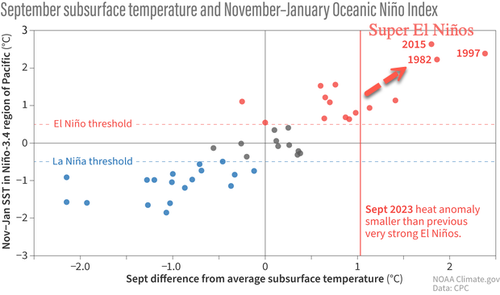
There is 3-in-10 chance this event could warm even further and become historically strong, or a so-called super El Niño, which means sea-surface temperatures would cross the 2 degrees Celsius (3.6 degrees Fahrenheit) warmer than average threshold. There have been three super El Niño winters since 1950 in 2015-16, 1997-98 and 1982-83.
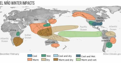
Here are the El Niño impacts across the US, including temperatures and rain/snow patterns:
Current El Niño strength versus 'super El Niños' that have formed over the decades - many of these super El Niños have resulted in major snowstorms across the Lower 48.
Local media outlet KUNC in Greeley, Colorado, spoke with Stephen Yeager, a project scientist with the center's Climate and Global Dynamics Laboratory, who highlighted the shifting weather patterns in the US because of El Niño and what it means this winter:
"The United States tends to get wetter and colder in the south, from California all the way across to Florida, whereas the northern part of the country from the state of Washington and across tends to be drier and warmer than normal," Yeager said. "States in the middle, like Colorado, don't have very strong connections to El Niño that are consistent."
The new El Niño event could either diminish or boost winter snowfall significantly, depending on how the weather pattern develops.
"We might see more snowfall sort of in the southern mountains of Colorado, maybe the southwest," Yeager said. "It's unclear exactly how far north that impact will reach. Whether we'll get a really epic snow year is hard to say, but I would say there's a potential to see extreme winter weather in one direction or another."
Yeager said this winter's event is expected to be comparable to the major El Niño of 1997 and 1998, one of the most powerful in history. That event caused massive flooding, drought, and other natural disasters at the time. The 1997-98 El Niño peaked at a three-month average of +2.4 degrees Celsius on the Niño 3.4 Index.
But Yeager said when it comes to the center's predictions, he makes no promises.
"Only time will tell if we're accurate," Yeager said. "But we believe our system has something to offer, and we're excited to be able to contribute this knowledge to the conversation going on right now about the impacts El Niño may have in the coming months."
At the beginning of the month, we cited one US meteorological analyst who said: "This is not a typical year. The 2023-2024 winter season is going to be very different" due to "2023-2024 winter is an El Nino pattern."
NOAA’s Climate Prediction Center forecasts a 75% to 85% chance of a ‘strong El Niño‘ between November and January. This weather phenomenon has led to more winter activity in parts of the US.
Courtesy of The Weather Channel, here are the main highlights of CPC’s report:
-
Forecasters from NOAA’s Climate Prediction Center still favor a strong El Niño late this fall into winter, or a 75-85% chance from November through January. That means the seasonal average of sea-surface temperatures in a certain region of the equatorial Pacific Ocean would be at or above the threshold of 1.5 degrees Celsius (2.7 degrees Fahrenheit) warmer than average.
-
NOAA says there is an 80% chance El Niño will last through spring (March-May).
-
There is 3-in-10 chance this event could warm even further and become historically strong, or a so-called super El Niño, which means sea-surface temperatures would cross the 2 degrees Celsius (3.6 degrees Fahrenheit) warmer than average threshold. There have been three super El Niño winters since 1950 in 2015-16, 1997-98 and 1982-83.
Here are the El Niño impacts across the US, including temperatures and rain/snow patterns:
Current El Niño strength versus ‘super El Niños’ that have formed over the decades – many of these super El Niños have resulted in major snowstorms across the Lower 48.
Local media outlet KUNC in Greeley, Colorado, spoke with Stephen Yeager, a project scientist with the center’s Climate and Global Dynamics Laboratory, who highlighted the shifting weather patterns in the US because of El Niño and what it means this winter:
“The United States tends to get wetter and colder in the south, from California all the way across to Florida, whereas the northern part of the country from the state of Washington and across tends to be drier and warmer than normal,” Yeager said. “States in the middle, like Colorado, don’t have very strong connections to El Niño that are consistent.”
The new El Niño event could either diminish or boost winter snowfall significantly, depending on how the weather pattern develops.
“We might see more snowfall sort of in the southern mountains of Colorado, maybe the southwest,” Yeager said. “It’s unclear exactly how far north that impact will reach. Whether we’ll get a really epic snow year is hard to say, but I would say there’s a potential to see extreme winter weather in one direction or another.”
Yeager said this winter’s event is expected to be comparable to the major El Niño of 1997 and 1998, one of the most powerful in history. That event caused massive flooding, drought, and other natural disasters at the time. The 1997-98 El Niño peaked at a three-month average of +2.4 degrees Celsius on the Niño 3.4 Index.
But Yeager said when it comes to the center’s predictions, he makes no promises.
“Only time will tell if we’re accurate,” Yeager said. “But we believe our system has something to offer, and we’re excited to be able to contribute this knowledge to the conversation going on right now about the impacts El Niño may have in the coming months.”
At the beginning of the month, we cited one US meteorological analyst who said: “This is not a typical year. The 2023-2024 winter season is going to be very different” due to “2023-2024 winter is an El Nino pattern.”
Loading…


