Goldman's Thomas Evans distributed a note to clients this morning highlighting that the latest weather models show the Arctic cold blast, in place last week, is "failing to persist" across portions of the Lower 48, which could potentially cap the recent natural gas price rally.
"A feature of winter weather in recent years has been an inability to persist cold patterns for two weeks at a time. This looks to continue with this upcoming cool stretch giving way to broad warmth returning across East and South in the 11-15 day," Evans wrote in the note.
He said, "The models have not broken down the strong West coast to Alaska ridging that had been instrumental in funnelling cold air from Canada into the US – and for the moment just have the cold air retreating back into Western Canada."
"If the ridging can be maintained there's a chance for another cold pattern for the East at the end of December, however the Polar Vortex is strong, which will make it harder to see serious cold spilling down from the Arctic," Evans noted.
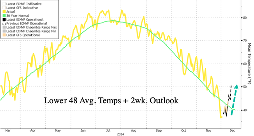
The latest weather models via Bloomberg show Lower 48 average temperatures are expected to rise above a 30-year trend into the mid-point of the month after a deep chill last week across the eastern part of the US.
Evans provided color on what's happening in NatGas markets:
The market needed to bring some production back ahead of the current cold shot, and priced to do so over the course of last week. With production >4.5 Bcf/d above it's low in early November, producers have provided some reassurance that they'll be active in cash. This reassurance coupled with a breakdown of the colder-than-normal weather pattern is being reflected in vol market softening today. While breakevens still look a little rich, call skew still scans as the more expensive expression in the front.
Meanwhile, in fixed price, we estimate CTAs flipped from short to long over the course of the past couple weeks – that new length looks vulnerable to any further deterioration in the weather outlook. If the balance of Dec rolls forward with a warmer outlook and Jan sells off below $3, the market will still want to keep some delivery risk (storm) premium in the F/H. With H/J already back to ~2c, this will put pressure on widening the J/F unless the market wants to take premia out of the C26. Given the path to balance tightening with LNG growth (and no new rigs going down in Haynesville) into X25H26, this (wider spreads, elevated back end) may be the right path forward, even though J/V is already wide for this point in the season.
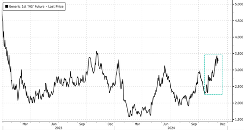
NatGas futures trading in New York has jumped 52% since mid-October due to cold weather trends across the Lower 48. Prices have since hit resistance around $3.50 per million British thermal units.
Latest NatGas coverage:
- NatGas Hits Highest Price In Year On "Very Cold Pattern Developing" Across Lower 48
- Goldman: "Keep Pressing" NatGas Shorts Amid Weakest October Demand In 61 Years
Keep an eye on 6-10-day and 8-14-day temperature outlooks via NOAA.
Goldman’s Thomas Evans distributed a note to clients this morning highlighting that the latest weather models show the Arctic cold blast, in place last week, is “failing to persist” across portions of the Lower 48, which could potentially cap the recent natural gas price rally.
“A feature of winter weather in recent years has been an inability to persist cold patterns for two weeks at a time. This looks to continue with this upcoming cool stretch giving way to broad warmth returning across East and South in the 11-15 day,” Evans wrote in the note.
He said, “The models have not broken down the strong West coast to Alaska ridging that had been instrumental in funnelling cold air from Canada into the US – and for the moment just have the cold air retreating back into Western Canada.”
“If the ridging can be maintained there’s a chance for another cold pattern for the East at the end of December, however the Polar Vortex is strong, which will make it harder to see serious cold spilling down from the Arctic,” Evans noted.
The latest weather models via Bloomberg show Lower 48 average temperatures are expected to rise above a 30-year trend into the mid-point of the month after a deep chill last week across the eastern part of the US.
Evans provided color on what’s happening in NatGas markets:
The market needed to bring some production back ahead of the current cold shot, and priced to do so over the course of last week. With production >4.5 Bcf/d above it’s low in early November, producers have provided some reassurance that they’ll be active in cash. This reassurance coupled with a breakdown of the colder-than-normal weather pattern is being reflected in vol market softening today. While breakevens still look a little rich, call skew still scans as the more expensive expression in the front.
Meanwhile, in fixed price, we estimate CTAs flipped from short to long over the course of the past couple weeks – that new length looks vulnerable to any further deterioration in the weather outlook. If the balance of Dec rolls forward with a warmer outlook and Jan sells off below $3, the market will still want to keep some delivery risk (storm) premium in the F/H. With H/J already back to ~2c, this will put pressure on widening the J/F unless the market wants to take premia out of the C26. Given the path to balance tightening with LNG growth (and no new rigs going down in Haynesville) into X25H26, this (wider spreads, elevated back end) may be the right path forward, even though J/V is already wide for this point in the season.
NatGas futures trading in New York has jumped 52% since mid-October due to cold weather trends across the Lower 48. Prices have since hit resistance around $3.50 per million British thermal units.
Latest NatGas coverage:
Keep an eye on 6-10-day and 8-14-day temperature outlooks via NOAA.
Loading…


