Florida needs to be prepared for tropical activity mid/late next week.
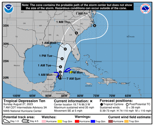
Tropical Depression 10 is "meandering" off the Yucatan Peninsula and is forecasted to become a hurricane early next week, with the latest spaghetti models suggesting landfall across the west coast of Florida and the Panhandle.
Overnight EURO ensembles on https://t.co/j6cXc9Fom0. Tracks solid. Main operational now under 990mb. Meaning a stronger Hurricane likely coming. Important thing to note. A strong fast moving Hurricane will have serious impacts inland. Intensifying storms don't lose much punch… pic.twitter.com/d99EFHqw5g
— Mike's Weather Page (@tropicalupdate) August 27, 2023
As of the latest National Hurricane Center update, TD10 is 30 miles south-southeast of Cozumel, Mexico, with winds sustained at 35 mph and moving south at five mph.
"The depression is moving toward the south near 5 mph (7 km/h), and it is likely to meander near the Yucatan Channel through early Monday. "A faster motion toward the north or north-northeast is expected later on Monday, bringing the system over the eastern Gulf of Mexico," the NHC forecast said.
In preparation for rapid intensification, Florida Gov. DeSantis declared a state of emergency for 33 Florida counties while campaigning for president in Iowa.
"I signed an Executive Order issuing a state of emergency out of an abundance of caution to ensure that the Florida Division of Emergency Management can begin staging resources and Floridians have plenty of time to prepare their families for a storm next week," DeSantis said.
Latest model landfalls still show anywhere from Apalachicola to Cedar Key, Florida is the main threat zone for #TD10 future #Idalia pic.twitter.com/3yzb3sUj3o
— Allan Huffman (@RaleighWx) August 27, 2023
He continued, "I encourage Floridians to have a plan in place and ensure that their hurricane supply kit is stocked."
Last week, tropical activity flourished across the Caribbean region and Atlantic basin after a "historic lull" this summer.
TROPICS | #Franklin is now a hurricane and #TD10 is prepping to enter the Gulf. Franklin will steer clear of the U.S., but T.D. 10 will strengthen to become Hurricane #Idalia with landfall likely in north Florida Wednesday. pic.twitter.com/VCsKn88to5
— Meteorologist Grant Gilmore (@GrantGilmoreWX) August 27, 2023
All eyes on Florida.
Florida needs to be prepared for tropical activity mid/late next week.
Tropical Depression 10 is “meandering” off the Yucatan Peninsula and is forecasted to become a hurricane early next week, with the latest spaghetti models suggesting landfall across the west coast of Florida and the Panhandle.
Overnight EURO ensembles on https://t.co/j6cXc9Fom0. Tracks solid. Main operational now under 990mb. Meaning a stronger Hurricane likely coming. Important thing to note. A strong fast moving Hurricane will have serious impacts inland. Intensifying storms don’t lose much punch… pic.twitter.com/d99EFHqw5g
— Mike’s Weather Page (@tropicalupdate) August 27, 2023
As of the latest National Hurricane Center update, TD10 is 30 miles south-southeast of Cozumel, Mexico, with winds sustained at 35 mph and moving south at five mph.
“The depression is moving toward the south near 5 mph (7 km/h), and it is likely to meander near the Yucatan Channel through early Monday. “A faster motion toward the north or north-northeast is expected later on Monday, bringing the system over the eastern Gulf of Mexico,” the NHC forecast said.
In preparation for rapid intensification, Florida Gov. DeSantis declared a state of emergency for 33 Florida counties while campaigning for president in Iowa.
“I signed an Executive Order issuing a state of emergency out of an abundance of caution to ensure that the Florida Division of Emergency Management can begin staging resources and Floridians have plenty of time to prepare their families for a storm next week,” DeSantis said.
Latest model landfalls still show anywhere from Apalachicola to Cedar Key, Florida is the main threat zone for #TD10 future #Idalia pic.twitter.com/3yzb3sUj3o
— Allan Huffman (@RaleighWx) August 27, 2023
He continued, “I encourage Floridians to have a plan in place and ensure that their hurricane supply kit is stocked.”
Last week, tropical activity flourished across the Caribbean region and Atlantic basin after a “historic lull” this summer.
TROPICS | #Franklin is now a hurricane and #TD10 is prepping to enter the Gulf. Franklin will steer clear of the U.S., but T.D. 10 will strengthen to become Hurricane #Idalia with landfall likely in north Florida Wednesday. pic.twitter.com/VCsKn88to5
— Meteorologist Grant Gilmore (@GrantGilmoreWX) August 27, 2023
All eyes on Florida.
Loading…


