When you think about areas with high population densities, certain regions spring to mind. This could be a populous part of Asia or a cluster of cities in North America or Europe.
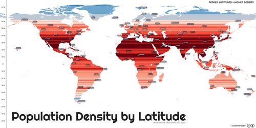
Usually density comparisons are made using cities or countries, but this map from Alasdair Rae provides another perspective. This world map depicts population density by latitude, going from the densest populated coordinates in deep red to the sparsest in light blue.
Why Certain Latitudes (and Regions) Are More Densely Populated
As Visual Capitalist's Anete Lusina details below, numerous factors affect an area’s population density. These can range from topography, or the physical terrain characteristics of the place, to more direct factors like an area’s climate, which can impact both the survivability and agricultural potential.
Political, economic, and social factors are also at play - for example, there is a natural lack of livelihood opportunities in sparse areas such as the Amazon rainforest or the Himalayas.
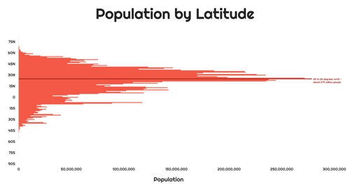
Breaking down the population by latitude, we see the population becomes more concentrated near the equator. In particular, the 25th and 26th parallel north are the most densely populated latitude circles. Around 279 million people reside in these latitude lines, which run through large countries like India, Pakistan, Bangladesh, China, the United States, Mexico, and others.
Despite their large landmasses, many of these countries do not themselves have very high population densities. Since density measures the ratio of people to physical space, countries with vast but sparse regions like China and India are less dense than imagined.
Out of the top 10 most densely populated countries in the world, only a couple can be found on the 25th and 26th parallel north—Bangladesh and Bahrain. For a size comparison, Bangladesh is 1.55% the size of China, and Bahrain is only 0.01%.
The Future of Population Density Near the Equator
Looking ahead to 2100, the UN projects that the global population will rise to almost 11 billion. This would increase global population density from 59.11 people per square kilometer in 2022 to 80.82 per square kilometer in 2010.
However, the projections show that Asia will not be the biggest contributor to this growth. Instead, the most considerable jump in population is predicted for Africa, set to grow by almost 200% from almost 1.5 billion people today to 4.3 billion in 2100.
The equator runs right through the middle of Africa and crisscrosses countries like the Congo (both the Republic and DRC), Kenya, Gabon, Uganda, and Somalia.
As Africa’s population expands, this means that at latitudes near the equator, there could be even higher population densities coming. Or course, this largely depends on how the world’s fastest growing cities—most of which are in Africa—shape up over the coming decades.
When you think about areas with high population densities, certain regions spring to mind. This could be a populous part of Asia or a cluster of cities in North America or Europe.
Usually density comparisons are made using cities or countries, but this map from Alasdair Rae provides another perspective. This world map depicts population density by latitude, going from the densest populated coordinates in deep red to the sparsest in light blue.
Why Certain Latitudes (and Regions) Are More Densely Populated
As Visual Capitalist’s Anete Lusina details below, numerous factors affect an area’s population density. These can range from topography, or the physical terrain characteristics of the place, to more direct factors like an area’s climate, which can impact both the survivability and agricultural potential.
Political, economic, and social factors are also at play – for example, there is a natural lack of livelihood opportunities in sparse areas such as the Amazon rainforest or the Himalayas.
Breaking down the population by latitude, we see the population becomes more concentrated near the equator. In particular, the 25th and 26th parallel north are the most densely populated latitude circles. Around 279 million people reside in these latitude lines, which run through large countries like India, Pakistan, Bangladesh, China, the United States, Mexico, and others.
Despite their large landmasses, many of these countries do not themselves have very high population densities. Since density measures the ratio of people to physical space, countries with vast but sparse regions like China and India are less dense than imagined.
Out of the top 10 most densely populated countries in the world, only a couple can be found on the 25th and 26th parallel north—Bangladesh and Bahrain. For a size comparison, Bangladesh is 1.55% the size of China, and Bahrain is only 0.01%.
The Future of Population Density Near the Equator
Looking ahead to 2100, the UN projects that the global population will rise to almost 11 billion. This would increase global population density from 59.11 people per square kilometer in 2022 to 80.82 per square kilometer in 2010.
However, the projections show that Asia will not be the biggest contributor to this growth. Instead, the most considerable jump in population is predicted for Africa, set to grow by almost 200% from almost 1.5 billion people today to 4.3 billion in 2100.
The equator runs right through the middle of Africa and crisscrosses countries like the Congo (both the Republic and DRC), Kenya, Gabon, Uganda, and Somalia.
As Africa’s population expands, this means that at latitudes near the equator, there could be even higher population densities coming. Or course, this largely depends on how the world’s fastest growing cities—most of which are in Africa—shape up over the coming decades.


