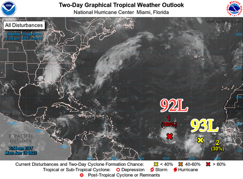
The National Hurricane Center is monitoring two tropical waves that formed off Africa in recent days and are heading west across the Atlantic Ocean. One has a very high probability of formation within the next 48 hours.
Tropical Wave 1, or Invest 92-L, is "midway between Africa and the Lesser Antilles and has become better organized overnight and is close to becoming a tropical cyclone," NHC wrote in a Monday morning update. The weather agency gives 92-L a 100% probability of formation within the next 48 hours.
"It's unusual in June to have a system (Invest #92L) on the verge of developing into a tropical depression or storm, let alone two. 92-L will head in the direction of the Caribbean over the next couple of days, but there are questions," Fox Weather meteorologist Bryan Norcross tweeted.
TROPICS UPDATE: It's unusual in June to have a system (Invest #92L) on the verge of developing into a tropical depression or storm, let alone two. 92-L will head in the direction of the Caribbean over the next couple days, but there are questions. More at pic.twitter.com/l85tml6Pg5
— Bryan Norcross (@bryannorcrosstv) June 19, 2023
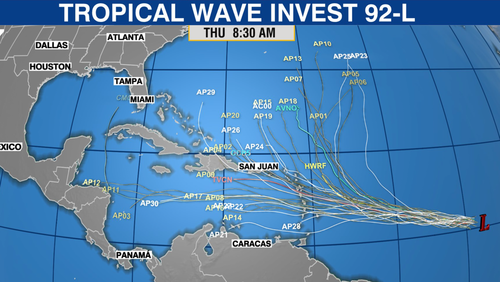
Computer models forecast 92-L's trajectory is likely the Caribbean Sea, but there are still a lot of uncertainties.
Phil Klotzbach, a hurricane forecaster at Colorado State University, said the early start for deep tropical development between the Caribbean and Cabo Verde off Africa indicates hurricane season could be active this year.
"[E]arly season activity in deep tropics is often a harbinger of a busy season," Klotzbach tweeted.
A big question is if warm Atlantic waters can generate strong enough storms to overcome wind shear produced by El Niño. Wind shear tends to tear apart storms.
The National Hurricane Center is monitoring two tropical waves that formed off Africa in recent days and are heading west across the Atlantic Ocean. One has a very high probability of formation within the next 48 hours.
Tropical Wave 1, or Invest 92-L, is “midway between Africa and the Lesser Antilles and has become better organized overnight and is close to becoming a tropical cyclone,” NHC wrote in a Monday morning update. The weather agency gives 92-L a 100% probability of formation within the next 48 hours.
“It’s unusual in June to have a system (Invest #92L) on the verge of developing into a tropical depression or storm, let alone two. 92-L will head in the direction of the Caribbean over the next couple of days, but there are questions,” Fox Weather meteorologist Bryan Norcross tweeted.
TROPICS UPDATE: It’s unusual in June to have a system (Invest #92L) on the verge of developing into a tropical depression or storm, let alone two. 92-L will head in the direction of the Caribbean over the next couple days, but there are questions. More at pic.twitter.com/l85tml6Pg5
— Bryan Norcross (@bryannorcrosstv) June 19, 2023
Computer models forecast 92-L’s trajectory is likely the Caribbean Sea, but there are still a lot of uncertainties.
Phil Klotzbach, a hurricane forecaster at Colorado State University, said the early start for deep tropical development between the Caribbean and Cabo Verde off Africa indicates hurricane season could be active this year.
“[E]arly season activity in deep tropics is often a harbinger of a busy season,” Klotzbach tweeted.
A big question is if warm Atlantic waters can generate strong enough storms to overcome wind shear produced by El Niño. Wind shear tends to tear apart storms.
Loading…


