Hurricane Idalia has made landfall in Florida’s Big Bend region Wednesday as a strong Category 3 storm.
Idalia made landfall near Keaton Beach in the Florida Big Bend around 7:45 a.m. It maintained its status as a “major” hurricane at the time of landfall with maximum sustained winds of 125 mph, according to the National Hurricane Center (NHC).
Landfall Keaton Beach, FL pic.twitter.com/7q1ox6HB75
— Jim Cantore (@JimCantore) August 30, 2023
Valdosta radar wind at 2500 feet over 100mph in the leftover eyewall. Extensive tree damage and power outages forthcoming. pic.twitter.com/GOgWtMHtIC
— Jim Cantore (@JimCantore) August 30, 2023
Hurricane #Idalia is making landfall as a strong Category 3 Hurricane.
The State Emergency Response Team stands ready to deploy search & rescue and power crews to impacted areas as soon as it is safe to do so. Follow @FLSERT for updates. pic.twitter.com/09S4iWwowm
— Ron DeSantis (@GovRonDeSantis) August 30, 2023
Hurricane-force winds extend 25 miles out from the storm’s center, but tropical storm-force winds are extending up to 175 miles out from there. However, as of 9:00 a.m., Idalia’s maximum sustained winds had diminished to 110 mph.
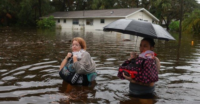
“Water levels along the coast of the Florida Big Bend are rising rapidly,” the NHC warned, pointing to a NOAA National Ocean Service tide gauge at Cedar Key reporting “water level of 5.9 feet above mean higher high water, which is an approximation of inundation in that area.”
7:45 AM EDT update: Extremely dangerous Category 3 Hurricane #Idalia makes landfall in the Florida Big Bend. Maximum sustained winds were estimated to be 125 mph. Catastrophic storm surge and damaging winds ongoing. pic.twitter.com/umMdj8dD5d
— National Hurricane Center (@NHC_Atlantic) August 30, 2023
The NHC added in an 8:00 a.m. update that the eye of the storm is expected to make its way to southern Georgia Wednesday afternoon or evening and move along the coasts of the Carolinas. It noted that the storm is expected to maintain its hurricane status as it reaches the Peach State.
Hurricane #Idalia Advisory 15A: Eye of Idalia Moving Just Inland From the Florida Big Bend Coast. Catastrophic Storm Surge and Damaging Hurricane-Force Winds Continue. https://t.co/tW4KeGe9uJ
— National Hurricane Center (@NHC_Atlantic) August 30, 2023
9 AM EDT Hurricane #Idalia Update: Catastrophic storm surge occurring along the coast of the Florida Big Bend and damaging winds spreading inland over northern Florida. pic.twitter.com/Ix3XH4VuwX
— National Hurricane Center (@NHC_Atlantic) August 30, 2023
Famed meteorologist Jim Cantore shared videos from Cedar Key, Florida, showing catastrophic flooding in the region, with water engulfing standing structures.
Water as far as the eye can see! #Idalia Cedar Key, FL pic.twitter.com/7D6rXfMMax
— Jim Cantore (@JimCantore) August 30, 2023
Incredible #Idalia storm surge 6’ and counting here at Cedar Key, FL pic.twitter.com/8MzaHJpWce
— Jim Cantore (@JimCantore) August 30, 2023
Gov. Ron DeSantis noted that the NHC is expecting storm surge to reach up to 16 feet in some areas, which officials have deemed “life-threatening.”
Governor Ron DeSantis Gives Update on Hurricane Idalia From Tallahassee Florida https://t.co/eeN2etJSvd
— Ron DeSantis (@GovRonDeSantis) August 30, 2023
RELATED — Hurricane Idalia Grows Stronger as It CHARGES Toward Florida
CSU/CIRA & NOAA via Storyful
“Meteorologists are also pointing to a rare blue supermoon which could further raise tides above normal levels just as Idalia pounds the coastline,” the AFP reports.
This story is developing.