The National Weather Service warned "paralyzing snowfall" will blanket parts of western and northern New York. Folks living in the cities of Buffalo and Watertown could be using yardsticks by the end of the weekend to measure the snow.
Lake-effect snow warnings have already been posted from Watertown to Buffalo-Niagara Falls to Erie, Pennsylvania, to northeastern Ohio.

"This will be the start of a prolonged lake-effect snow event which will likely include paralyzing snowfall for the Buffalo and Watertown areas late this week through the weekend," NWS wrote in a Wednesday morning note.
NWS' use of words such as "crippling" and "paralyzing" to describe the lake-effect snowstorm's potential is very ominous.
Liz Jurkowski, a meteorologist at NWS' Buffalo office, told NYTimes that NWS' use of words is "very rare."
"We usually don't pull these terms out except for historic events," Jurkowski said.
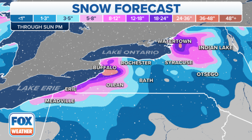
Snow begins Wednesday night and will continue through Saturday for Buffalo and Watertown. These areas could see between 1 and 3 feet of snow. Here's more on possible snow totals via FOX Forecast Center:
The highest totals will likely be centered directly over the Buffalo and Watertown metro areas because of the nearly stationary bands of snow from Thursday night through Friday night. Between 1 and 3 feet of snow is expected to pile up by Sunday afternoon, with localized amounts of up to 4 feet not ruled out.
Jurkowski said residents in Buffalo and Watertown could expect "thundersnow" and high snowfall rates. Maybe now is the time to buy supplies and hunker down.
The National Weather Service warned “paralyzing snowfall” will blanket parts of western and northern New York. Folks living in the cities of Buffalo and Watertown could be using yardsticks by the end of the weekend to measure the snow.
Lake-effect snow warnings have already been posted from Watertown to Buffalo-Niagara Falls to Erie, Pennsylvania, to northeastern Ohio.
“This will be the start of a prolonged lake-effect snow event which will likely include paralyzing snowfall for the Buffalo and Watertown areas late this week through the weekend,” NWS wrote in a Wednesday morning note.
NWS’ use of words such as “crippling” and “paralyzing” to describe the lake-effect snowstorm’s potential is very ominous.
Liz Jurkowski, a meteorologist at NWS’ Buffalo office, told NYTimes that NWS’ use of words is “very rare.”
“We usually don’t pull these terms out except for historic events,” Jurkowski said.
Snow begins Wednesday night and will continue through Saturday for Buffalo and Watertown. These areas could see between 1 and 3 feet of snow. Here’s more on possible snow totals via FOX Forecast Center:
The highest totals will likely be centered directly over the Buffalo and Watertown metro areas because of the nearly stationary bands of snow from Thursday night through Friday night. Between 1 and 3 feet of snow is expected to pile up by Sunday afternoon, with localized amounts of up to 4 feet not ruled out.

Jurkowski said residents in Buffalo and Watertown could expect “thundersnow” and high snowfall rates. Maybe now is the time to buy supplies and hunker down.